


The UN’s overwhelming vote for Equal Earth was never just about maps. America’s lone objection made that impossible to ignore.
A map is supposed to tell us where things are. It rarely tells us what we are supposed to think about them.
That is the uncomfortable lesson sitting beneath the United Nations General Assembly’s extraordinary 164-1 vote last Friday to promote a more accurate representation of the world, particularly Africa.
The resolution, led by Togo and backed by the African Union, encourages governments, schools, international organisations and technology companies to use map projections that better preserve the relative size of continents. The Equal Earth projection is the obvious beneficiary.
Six countries abstained.
One voted no.
The United States!
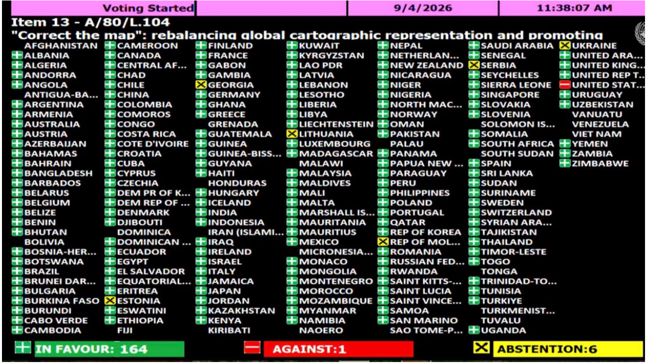
And that lonely vote may have done more for the argument behind the resolution than the 164 yes votes ever could.
The US described the initiative as part of a “much larger and more radical ideological project”, arguing that the UN should be concentrating on “genuine problems of international peace, prosperity, or good relations”. Its representative also dismissed the effort as an “anodyne” attempt to update cartographic proportions.
There is an irony here that is difficult to miss.
For years, critics of the Mercator projection have argued that maps are not neutral objects. They are choices. Every projection decides what to preserve and what to sacrifice because the spherical Earth cannot be flattened onto a page without distortion.
Mercator preserves direction and was revolutionary for navigation. That is not in serious dispute. Created by Gerardus Mercator in 1569, it helped sailors plot routes using constant compass bearings.
The problem came when a useful navigational tool became a supposedly universal picture of the world.
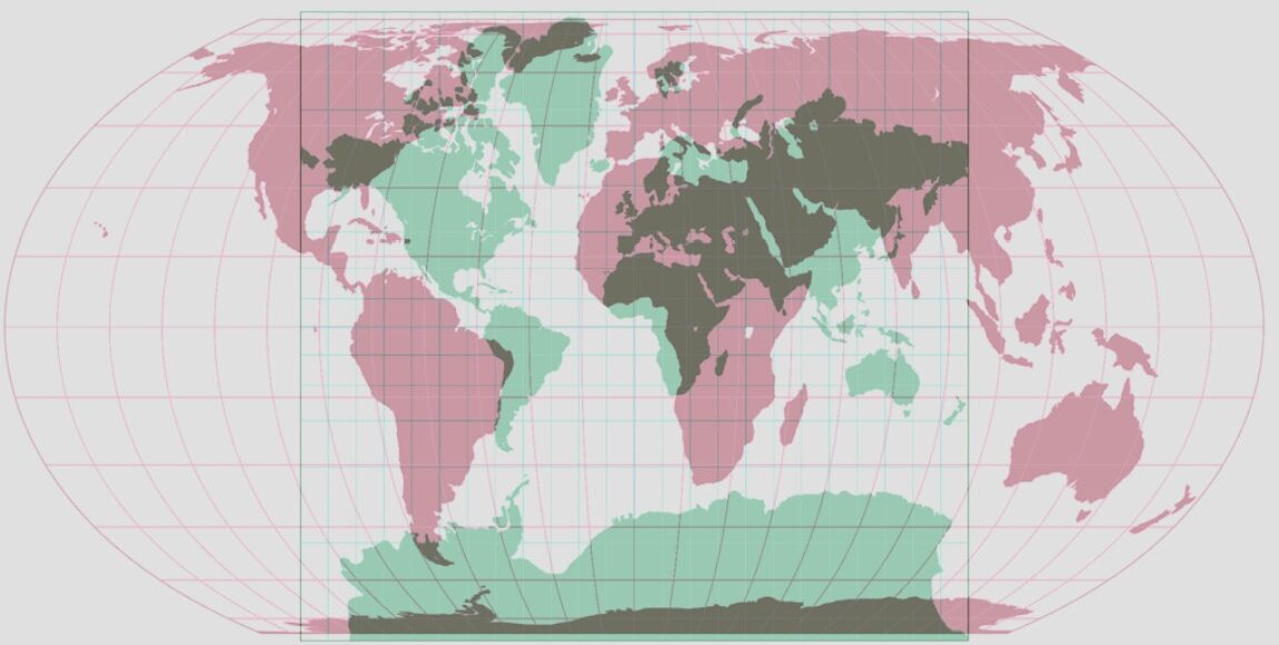
Suddenly, Greenland could look roughly comparable to Africa even though Africa is about 14 times larger. Europe and North America appeared vastly larger than their actual proportions, while equatorial regions were visually diminished.
That distortion is mathematical, not a conspiracy.
But what societies do with mathematical distortions can become political.
Equal Earth projection and the politics of seeing
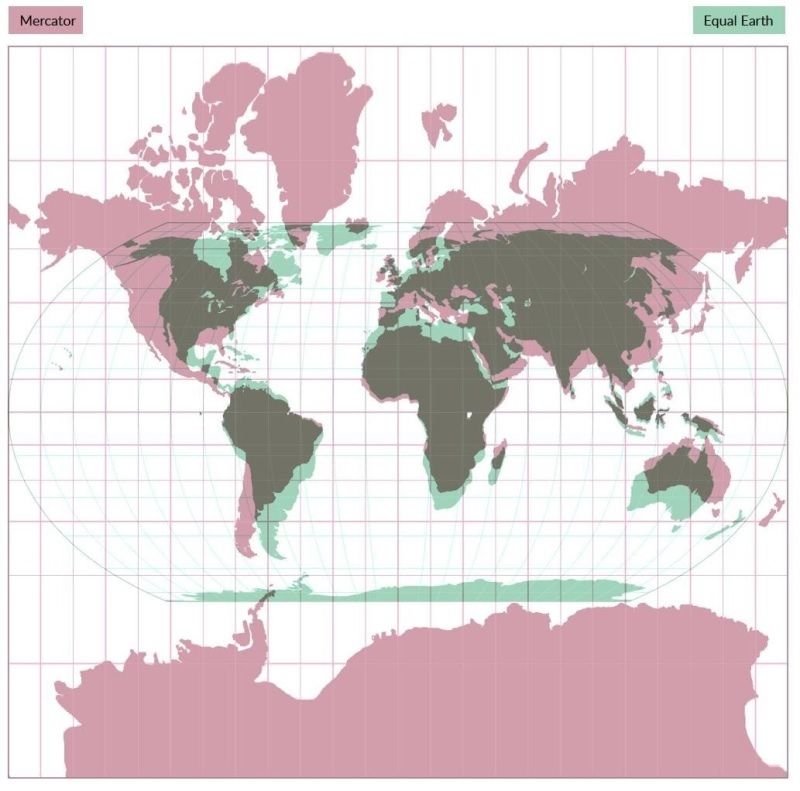
This is where the Equal Earth projection enters the argument.
Developed in 2018 by Bojan Šavrič, Tom Patterson and Bernhard Jenny, Equal Earth is an equal-area projection. It preserves the relative size of land masses far better than Mercator, although it sacrifices other qualities such as the precise shape of continents.
It is not a perfect map because there is no perfect flat map of a spherical planet.
That point matters.
The UN has not discovered the one map that finally tells the absolute truth. Nor has it banned Mercator. The resolution explicitly recognises that Mercator remains useful for maritime and aerial navigation.
What it has done is challenge the idea that the map most useful for sailors should automatically remain the map most useful for teaching children what the world looks like.
That is a reasonable challenge.
The deeper question is why this should provoke such an ideological response.
Cartography has a long relationship with power, particularly in Africa. Historians have documented how mapping became increasingly important to colonial administration, helping European powers organise territory, resources and populations according to colonial priorities. Oxford’s research on cartography in colonial Africa describes maps as instruments that helped translate colonial visions of territory into mechanisms of political and economic control.
This does not mean Mercator was invented as an anti-African weapon.
It was not.
That is precisely why the argument needs nuance.
Gerardus Mercator did not sit down in the 16th century and decide that Africa should look small. His projection solved a genuine navigational problem.
But a map can have consequences beyond the intentions of the person who drew it.
The Mercator projection’s later use as a general-purpose world map, particularly in classrooms, atlases and public institutions, helped normalise a visual hierarchy in which countries closer to the poles appeared much larger than they actually were. Scholars have long noted how its inappropriate use beyond navigation contributed to perceptions that inflated Europe and North America.
So when African governments say, in effect, “We would like the world to see Africa at its actual size,” the appropriate response should not be panic.
It should be: fair enough.
Equal Earth projection and the lonely American objection
This is why the American objection is so revealing.
Washington is entitled to believe that the UN should focus on wars, poverty, trade, security and other urgent matters. It is also entitled to question whether a General Assembly resolution about cartographic representation is the best use of diplomatic energy.
There is a legitimate argument there.
No map projection will feed a hungry child. Changing a classroom map will not create a job. It will not end conflict or erase the structural inequalities facing African countries.
And there is a danger in turning every historical symbol into a political battlefield.
But the US argument becomes harder to sustain when the correction itself is treated as an ideological threat.
Because that is precisely what the campaign was asking the world to examine: the assumptions hidden inside things that appear ordinary.
The campaign was not simply saying that Mercator is wrong.
It was asking why a map designed for a specific navigational purpose became the default visual language through which billions of people learned the size and importance of the world.
That distinction is crucial.
The United States did not create Mercator. America did not spend 450 years deliberately shrinking Africa.
But the modern international system inherited the map, normalised it and used it extensively. The US, as one of the most powerful countries in that system, has also benefited from a global visual culture in which the northern industrialised world occupies an enormous amount of visual real estate.
And then, when 164 countries say they would like to correct that imbalance, America becomes the lone dissenter.
That is the contradiction.
The lonely “No” did not disprove the campaign’s argument.
It inadvertently illustrated it.
Equal Earth projection is about more than geography
There is something almost poetic about the fact that the argument has emerged from Africa.
For centuries, Africa has been described through other people’s categories: the Dark Continent, the underdeveloped continent, the aid-dependent continent, the continent of crisis and even wrongly perceived as a country.
Some of those descriptions have contained elements of reality. Many have also become lazy shorthand.
Representation matters because repetition becomes perception.
If a child repeatedly sees Africa represented as smaller than it is, while Europe and North America dominate the map, that image becomes part of the mental architecture through which the world is understood.
Nobody needs to tell the child that one region matters more.
The picture can do some of the work.
That is why Togo’s Foreign Minister Robert Dussey was right to insist that the campaign is ultimately about how the world sees itself. As he put it after the vote, “A fair map does not change the geography of the world, it changes how we see the world.”
That may sound grandiose for a map.
It is not.
Maps have always been more than drawings. They have defined borders, enabled conquest, organised territories, directed armies, facilitated trade and shaped people’s understanding of distance and importance.
The colonial history of cartography in Africa makes that particularly clear.
So perhaps the most important thing about the Equal Earth projection is not whether every school in Africa replaces its Mercator map tomorrow.
It is that people are finally asking a basic question:
Who decided that this was what the world should look like?
The answer, as it turns out, is not simply cartographers.
It is history.
And history is never as neutral as the map makes it appear.
The UN resolution will not transform global power. It will not decolonise education by itself. It will not make Africa richer, safer or more influential.
But it can do something smaller and more fundamental.
It can correct the picture.
And sometimes correcting the picture is where correcting the story begins.
The most striking part of Friday’s vote, therefore, may not be that 164 countries voted yes.
It may be that only one country voted no.
When almost the entire room agrees that the world can be represented more accurately, the lone objection deserves scrutiny.
Not because America is uniquely responsible for the map.
But because its objection has turned a debate about cartography into something much larger.
It has reminded us that maps are never merely about where countries are.
They are also about how much space we believe those countries deserve to occupy in our imagination.

What a piece!